Tag
Select an Option
1001 Mine
1st Street
24 Hours of Aspen
2nd Street
3rd Street
4-H Club
4th Street
5th Street
6th Street
7th Street
8th Street
Agate Lodge
Alpine Bank
Alpine Jeweler
Alpine Mountain Market
American Legion
American Red Cross
America's Downhill
America's Uphill
Anderson Ranch
Anderson Stables
Andre's Building
Argentum-Juniata Mine
Art Cart Derby
Ashcroft
Aspen Airport Business Center (AABC)
Aspen Alps
Aspen Animal Shelter
Aspen Art Museum (Aspen Center for Visual Arts)
Aspen Camp School for the Deaf
Aspen Center for Environmental Studies (ACES)
Aspen Center for Physics
Aspen Center for Visual Arts (use Aspen Art Museum)
Aspen Chamber Resort Association (ACRA)
Aspen Chapel (Use Prince of Peace)
Aspen Club
Aspen Community Church
Aspen Community Theater (ACT)
Aspen Company
Aspen Country Day School
Aspen Country Inn
Aspen Cycling (Velo) Club
Aspen Daily News
Aspen Drug
Aspen Elementary School
Aspen Foundation (Aspen Valley Foundation)
Aspen Golf Course
Aspen Grove Cemetery
Aspen Grove Subdivision
Aspen Hall of Fame
Aspen High School
Aspen Highlands
Aspen Historical Society
Aspen Hose Team
Aspen Ice Garden/ Brown Ice Palace
Aspen Ideas Festival
Aspen Institute
Aspen Junior Hockey
Aspen Lumber Company
Aspen Magazine
Aspen Meadows
Aspen Middle School
Aspen Mine
Aspen Mountain Lodge
Aspen Mtn.
Aspen Music Festival and School
Aspen Pedestrian Mall
Aspen Pitkin County Housing Authority (APCHA)
Aspen Recreation Center (ARC)
Aspen Saddle and Bridle Club
Aspen Santa Fe Ballet
Aspen Skating Club
Aspen Skiing Company (Aspen Ski Corp.)
Aspen Smelting Co.
Aspen Society for Animal Rights (ASFAR)
Aspen Sports
Aspen State Bank
Aspen State Teacher's College
Aspen Street
Aspen Street Racing
Aspen Street Railway (horse-drawn trolley)
Aspen Times (Business)
Aspen Times Building
Aspen Transfer and Coal
Aspen Union Era
Aspen Valley Hospital
Aspen Valley Hospital (Castle Creek Road)
Aspen Wine & Spirit Company
Aspen Words
Aspen Yacht Club
Aspen Youth Center
AspenOUT and LBGTQ
AT&T Skiing Award
Aztec Ski Run
Ballet West
Ballet/Aspen aka DanceAspen
Baptist Church (First)
Basalt
Beard Block
Beck Brothers Grocery
Bell Mountain Chairlift
Bell Mtn. (Face, Back, Ridge or Shoulder)
Bentley's
Big Burn (Run or Lift)
Bleeker Street
BMC West Lumber Yard
Boat Tow
BOLD Handicap Ski Program
Bonnie's (aka Gretl's)
Boogie's Diner
Boomerang Lodge
Bowman's Musee and Saloon
Box L Ranch
Boy Scouts or Girl Scouts
Brush Creek
Burlingame Ranch (Ranches and Subdivision)
Busk-Ivanhoe Tunnel
Buttermilk Mtn.
Capitol Hill Addition
Capitol Peak
Carbondale
Carl's Pharmacy
Castle Creek
Castle Creek Power House
Cathedral Lake
Cathedral Peak
Cemetery Lane
Centennial Apartments
Chalet Lisl
Challenge Aspen
Chitwood Block
Christ Episcopal Church
Christiana Lodge (Christiania)
Christmas Inn
Citizens Hospital
City Council
City Market
Civilian Conservation Corps (CCC)
Clarendon Hotel
Clark's Market
Cliffhouse Restaurant
Cloud Nine (Restaurant or Lift)
Collins Block
Colorado Division of Wildlife
Colorado Midland Railroad Depot
Colorado Mountain College (CMC)
Colorado National Bank
Colorado River
Columbine Lodge
Community Church
Community Garden
Community Office for Resource Efficiency (CORE)
Community School
Compromise Mine
Connor's Addition
Continental Inn
Conundrum (Pass, Hot Springs, etc.)
Cooper Ave. Bridge
Cooper Avenue
Coors Classic Road Race
Copper Kettle Restaurant
Corkscrew Ski Run
COVID-19 Pandemic
Cowenhoven Tunnel
Crater Lake
Crestahaus Lodge
Crested Butte
Crystal City Club
Crystal Palace
Crystal River and Town
DanceAspen Festival
Dean Street
Deane's Addition
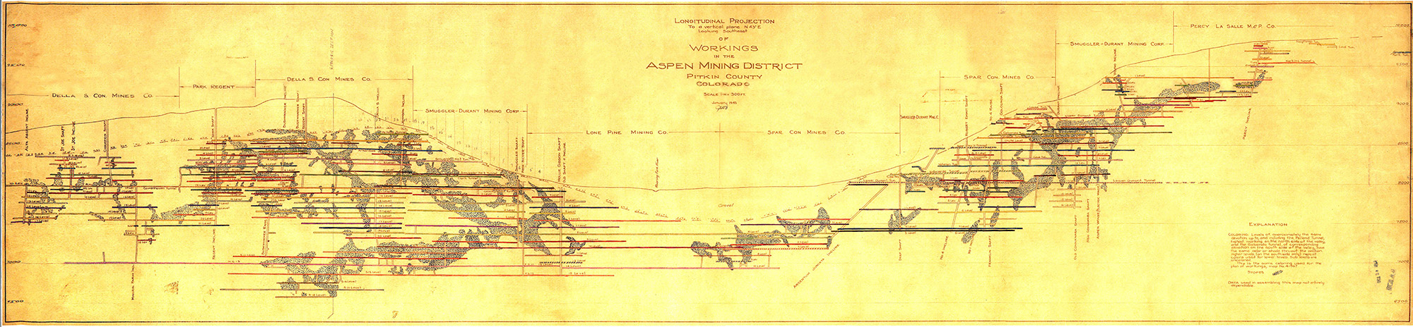
Della S. Consolidated Mining Company
Delta Kappa Gamma Society
Denver
Development of Pitkin County
Devil's Punch Bowl
Dicken's Carolers
Doerr-Hosier Center
Dolinsek Gardens
Durant Avenue
Durant Mine
Eagle's Club FOE#184
Eame's Addition
East Aspen Addition
El Jebel
Elks Club BPOE #224
Elli of Aspen
Emma
Emmet Block
Enterprise Mining Company
Epicure Restaurant
Episcopal Church
Erickson Ranch
Exhibition Ski Run & Chairlift
Fanny Hill (Run or Lift)
Farmer's Market (use Saturday Market)
Fifth Avenue Condominiums
Filmfest
Finley & Rose
Fire 1919
Fire 1941
Fire 2018 (Lake Christine)
Fire Department
First Baptist Church
First Methodist Episcopal Church
First National Bank (Brand Building)
First National Bank (Central Bank, US Bank)
FIS 1950
FIS World Cup Finals 2017
Fishhouse Punch Party
Food & Wine Festival
Four Seasons Club
Francis Street
Franklin Mine
Free Silver Mining Company
Fryingpan River
Galena Street
Garfield School
Garmisch Street (Center Street)
Gay '90s Residence
Gazebo
Gentlemen of Aspen Rugby Club
Gentry Brothers Dog and Pony Show
Gerbaz Ranch
Gibson Ave.
Gibson Girl Residence
Gillespie Street
Given Institute (use Aspen Center for Physics)
Glenwood
Glenwood Canyon
Glory Hole
Glory Hole Lodge
Goethe Bicentennial
Golden Horn Restaurant
Grand Army of the Republic
Grand Aspen Hotel/ Hyatt
Grand Prix Ski Run
GrassRoots TV
Great Gatsby Party
Guido's Swiss Inn
Hagerman Mtn
Hagerman Pass
Hallam Lake
Hallam Street
Hallam's Addition
Hanging Lake
Hanging Rock
Hard Rock Cafe
Harris Concert Hall
Hearthstone House
Heroes (Pandoras)
Herron Park
Hickory House
High Alpine Restaurant or Lift
High Bridge, Independence Pass
Highland Bavarian Lodge
Highland Bowl
Highland City
Highlands
Highway 82
Holden Lixiviation Plant
Holden Marolt Property
Holland House
Homecoming
Hope Mine
Hopkins Avenue
Hotel Aspen
Hotel Jerome Bar
Hotel Jerome Pool
Hub of Aspen
Hughes Addition
Hunter Creek
Hunter Creek Power House Building
Hunter Street
Hut System
Hyman Avenue
I.O.O.F. (Independent Order of Odd Fellows)
Ibex Mine
Independence Ghost Town
Independence Pass
Independence Pass Foundation (IPF)
International Design Conference (IDCA)
Interski 1968
Isis Theater
J.B. Wheeler Banking Co.
J.D. Hooper Hook and Ladder Company
Jaffee Ranch
James E. Moore Pool
Jazz Aspen
John Denver Sanctuary
Johnson Bonnell Groceries
July 4th (Independence Day)/ Fourth of July
KJAX Aspen Public Radio
KSNO Radio
KSPN Radio
Koch Lumber Company
Koch Park
Krabloonik
L'Auberge Hotel Durant
La Cocina
LaFave Block
Ladies Aid Society
Lake Ave.
Lazy Chair Ranch
Leadville
League of Women Voters
Lenado
Les Dames d'Aspen
Lift 1 A
Lift One
Lift Six (FIS Lift)
Lift Three (Ajax Express)
Lift Two
Limelite Lodge (Limelight)
Lincoln Gulch
Lincoln School
Lions Club
Little Annie Mine & Basin
Little Annie's Restaurant
Little Nell
Little Nell Chairlift (#4)
Little Nell Ski Run
Little Percent Taxi Company
Little Red School House
Loges Peak (top of Highlands)
Lutheran Church
Magnifico Sport Shop
Main Street
Main Street Bakery
Marble
Mario's
Marolt Ranch
Maroon Bells
Maroon Creek
Maroon Creek Bridge
Maroon Creek Bridge (2008)
Maroon Creek Bridge/Trestle
Maroon Lake
Maroon Peak
Masonic Lodge
Matthew Drug
McLain Flats
McSkimming Road
Meadowood
Merry Go Round Restaurant
Mesa Store
Messiah Lutheran Church
Mezzaluna
Midland Ave.
Midland Ranch
Midnight Mine
Mill Street
Mill Street Bridge
Mineral Farm Mine
Mollie Gibson Mine
Monarch Street
Montessori Pre-School
Montezuma Basin
Moore Open Space
Mother Lode Restaurant
Mother Lode Volleyball Tournament
Mother Puckers
Mountain Chalet
Mountain Rescue
Mountain Valley
Mt. Baldy
Mt. Daly
Mt. Hayden
Mt. Sopris
Music Tent (Saarinen, Bayer-Benedict, Benedict aka Michael Klein)
NASTAR
Natal Ranch
National Championships 1941
Neale Street Bridge
Newman Mine
Niagra Ski Run
No Problem Bridge
North Forty
North of Nell
North Street
Norway Lodge
Obermeyer Skiwear
Oklahoma Flats
Old Snowmass
Original Street
Owl Creek
PV Aspen & Aspen Mtn.
PV Aspen from Aspen Mtn.
PV Looking either East or West
Paepcke Park
Paradise Bakery
Park Ave.
Park Tunnel Mine
Parlour Car Restaurant
Pearl Pass
Pearl Street
Pine Creek Cookhouse
Pioneer Park
Pitkin County Bank
Pitkin County Commissioners
Pitkin County Court
Pitkin County Fair
Pitkin County Jail
Pitkin County Library
Pitkin County Sheriff
Pitkin County Treasurer
Pitkin Green
Plumtree Inn
Police Department
Popcorn Wagon
Post Office
Potato Days
Powder Pandas
Pride of Aspen Mine
Prince of Peace Chapel (Church)
Prospector Lodge
Pyramid Peak
Quicksilver Taxi Company
RFTA (Roaring Fork Transit Authority)
Race Track
Race for the Cure
Red Brick- School / Center for the Arts / Recreation Center
Red Butte Cemetery
Red Mtn.
Red Onion
Redstone
Regent Mine
Rifle, CO
Rink Opera House
Rio Grande Park
Rio Grande Place
Rio Grande Trail
Ritz Carlton Highlands
Riverside Addition
Riverside Drive
Roaring Fork River
Roch Cup
Roch Run
Rocky Mountain Institute (RMI)
Rotary Club
Rubey Park Bus Station
Ruby (Ghost Town)
Ruedi Reservoir
Ruggerfest (Aspen)
Rust Sampling Works
Ruthie's (Run or Lift)
Ruthie's Restaurant
S-Curves
Sabbatini Sports
Salvation Ditch
Sardy Field (Pitkin Co. Airport)
Sardy House
Saturday Market
Schiller Mining Company
Shadow Mtn.
Shale Bluffs
Shaw Coal & Feed
Sheely/Ron Krajian Bridge
Shield-O Ranch
Shlomos Restaurant
Silver King Mine
Silver Queen Gondola
Silver Queen Statue
Sister Cities
Ski Racing, Professional
Ski Racing, Misc. Events
Ski Swap
Ski-Vu Lodge
Skier's Chalet
Skiff Ranch
Slaughterhouse Bridge
Smuggler Inn
Smuggler Mine
Smuggler Mtn.
Smuggler Racquet Club
Smuggler Street
Smuggler Trailer Park
Smuggler Zinc Concentrator
Snowbunny Lane or Subdivision
Snowflake Lodge
Snowmass Bike Park
Snowmass Canyon
Snowmass Chapel
Snowmass Creek
Snowmass Lake
Snowmass Mall
Snowmass Peak and/or Mountain
Snowmass Rodeo
Snowmass Ski Area
Snowmass Village
Spar Consolidated Mining Co.
Spar Gulch Ski Run
Spring Street
St. Benedict's Monastery
St. Mary's Catholic Church
St. Regis Hotel
St. Stephen's Catholic Church
Stapleton Homestead
Starwood
Steeplechase
Stein Ranch
Sterner Ranch
Stewart Title
Stillwater (Northstar Nature Preserve)
Sundeck
Sunshine Peak
T Lazy 7 Ranch
Tagert Hut
Tagert Livery Stable
Take Two Video
Taylor Lake/Pass
Terese David's
Texaco Gas Station
The Argentine Insurance Co.
Theatre Aspen
Thrift Shop of Aspen
Thunderbowl
Tiehack
Tim Kelleher's Saloon
Tipple Inn
Tipsy Taxi
Toklat
Tom Latta's Brick Saloon
Tomkin's Hardware
Tour de Rump
Tourtelotte Park
Trentaz Ranch
Twin Lakes
Tyrolean Lodge
US Ski Team
USFS
Ute Avenue
Ute Cemetery
Ute City Bar and Grill
Ute Peak or Trail
Vagneur Ranch
Vail, CO
Veteran Mine
Village Express Chairlift
W/J Rodeo
Wagner Park
Warren Lake
Waters Ave.
Watson Divide
West Buttermilk
West End
Western State College of Colorado
Wheeler-Stallard House Museum
Wienerstube Restaurant
Wildcat Ranch
Wilderness Workshop
Wildwood Preschool
William's Addition
Williams Ranch
Willoughby Jump
Windsor Hotel
Windstar
Wine Party
Winternational
Women of Woodcraft
Woodmen of America
Woodmen of the World
Woody Creek
Woody Creek Raceway
World Cup
World's Fair Bakery
X Games
Yellow Brick School
Yule Marble Quarry
Subject
Select an Option
A-frame
Accessory
Accordion
Advertisement Aerobics
Airplane
Ambulance
Antlers
Architecture
Art
Aspen Idea
Automobile
Avalanche
Awning
Axe
Baby
Backyard
Bakery
Ballet
Balloon
Balloon, Hot Air Band
Banjo
Bank
Banner
Barn
Barrel
Baseball
Basketball
Bear
Beard
Bed
Beer
Bell
Bench
Bicycle or Biking Biking, Mountain Biking, Road
Bingham Cup
Birthday
Blacksmith
Board, Diving
Boat
Book
Boot
Boot, Ski
Bottle
Bowling
Box
Brand, Animal
Broom
Bucket
Bull
Bus
Bush
Business
Button
Button, Political
Cabin
Cake, Birthday
Calculator
Calendar
Camel
Camera
Camping
Can
Can, Paint
Can, Trash
Cane
Cannabis (use Marijuana) Canoe
Car, Ore
Carriage
Cart
Case
Cat
Cattle
Celebrity
Cellar, Root
Chair
Chair, Wheel
Chalet
Cheerleading
Chicken
Child
Chimney
Christmas
Climbing
Clock
Cloth
Clothes
Clothes, Wedding Cloud
Clown
Coal
CocaCola (Coke) Cocaine
Communications Computer
Condominium
Conference
Construction
Container
Cooking
Corral
Costume
Counter
Cow
Cowboy
Coyote
Craft
Creek
Crowd
Crutches
Cup
Currency
Curtain, Lace
Dam
Dance or Dancing
Dandelion
Daycare
Deck
Decor
Deer
Depot
Design
Desk
Dining
Diploma
Disk
Diver, Deep Sea
Dog
Dog Sledding/Mushing Donkey
Door
Drawing
Dress
Dresser
Drugs, Illegal
Duck
Easter
Electronic
Elk
Emigration
Entertainment
Equipment, Earthmoving Equipment, Hospital
Equipment, Ice Cutting
Equipment, Mining
Equipment, Ranching
Equipment, Set Design Equipment, Skiing
Equipment, Snow Making Eyeglasses
Fan
Fashion
Fashion, 1890s
Fashion, 1900s
Fashion, 1910s
Fashion, 1920s
Fashion, 1930s
Fashion, 1940s
Fashion, 1950s
Fashion, 1960s
Fashion, 1970s
Fashion, 1980s
Fashion, 1990s
Fashion, 2000s
Fashion, 2010s
Fashion, Fur
Fashion, pre 1890
Fence
Ferrari
Festival
Fireplace
Fireworks
Fish or Fishing
Flag
Flag, American
Flag, Colorado
Flower, Carnation Flower, Peonie
Flower, Wild
Flowers
Food
Football
Fountain
Fountain, Soda
Frisbee
Funeral
Fur
Furnishing
Game, Board
Game, Card
Garden
Gas Station
Gates
Girl
Glass
Gloves
Go-Kart
Goggles
Golf
Graduation
Grandstand
Grass
Guitar
Gun
Gymnastics
Hair
Halloween
Hang gliding/Parasailing Hardware
Hat
Hat, Top
Hay
Headstone
Health
Helicopter
Helmet, Ski
Hide, Animal
Highchair
Hiking
Hillside
Hockey
Horse
Horseback Riding
Hose
House, Bird
Hunting
Hydrant, Fire
Hygiene
Ice Skating (use Skating, Ice)
Indian
Infant
Instrument, Musical
Jail
Jeep or Jeeping
Jewelry
Jogging (use Running)
Jug
Juggling
Jumping
Jumping, Ski
Kayak or Kayaking
Key
Kitchen
Knife
Lacrosse
Ladder
Lamp
Laundry
Leaf, Aspen
Letter
License, Transportation
Light
Light, Street
Light, Traffic
Lighter
Lilacs
Lip Stick
Magazine
Mail Box
Map
Marijuana
Martial Arts
Mask
Mat
Match
Medal
Megaphone
Memorabilia
Merchandise
Microphone
Miner
Minority
Mirror
Motorcycle
Mountain Lion Movie/TV
Mud
Mule
Music
Mustache
Napkin
Necklace
Necktie
Newspaper
Nightlife
Notebook
Nurse
Opera
Ornaments, Christmas
Overalls
Owl
Paddleboarding
Pail
Palm tree
Panabode
Panel, Solar
Parachuter
Parade
Park
Photograph or Photography Piano
Picnic or Outing
Picture
Pier
Pig
Pin
Pipe, Stove
Pipe, Tobacco
Pitcher
Pitchfork
Plant
Plate
Plate, License
Playground
Podium
Pole, Flag
Pole, Ski
Pole, Telegraph Pole, Utility
Polo
Pond
Pony
Pool
Porch
Portrait
Postcard
Potatoes
Powder (Skiing) Prank
Present
Press
Ptarmigan
Pump, Gas
Purse
Quilt
Raccoon
Raft or Rafting Raquetball
Recipe
Refrigerator
Register, Cash
Rock
Rodeo
Romantic Novel
Rugby
Running (Track & Jogging) Sack
Saddle
Sailing
Santa Claus
Saw
Science
Sculpture
Seeds
Senior Citizen
Shade, Window
Shadow
Sheep
Sheep, Bighorn
Shelf
Shoes
Shopping
Shovel
Shrub
Sidewalk
Sign
Sign, Instructional
Sign, Political
Sign, Street
Sign, Trade
Sign, Traffic
Silver
Skateboarding
Skating, Roller
Ski Joring
Sled/Sleigh
Smoke
Smokestack
Snow
Snowcat
Snowmobile
Snowshoeing
Soccer
Socks
Softball
Space
Spoon
Sprinkler
Stable
Staircase
Statue
Statue, Civil War Stereo
Stereocard
Sticker
Sticking Tommy Streamer
Stroller
Suitcase
Sunglasses
Swimming
Table
Tank, Water
Taxi
Teacher
Technology
Teepee
Telemarking
Telephone
Telephone, Pay
Tennis
Tent
Terrain Park
Thanksgiving
Theatre
Tire
Tool
Top Hat (use Hat, Top) Toy
Track (use Running)
Tracks, Railroad
Traffic
Trail
Travel
Tree
Tree, Aspen
Tree, Blue Spruce
Tree, Christmas
Tree, Cottonwood
Tree, Ski Boot
Triathlon
Trophy
Truck
Truck, Fire
Tunnel
Turet
Turkey
Typewriter
Umbrella
Uniform
Uniform, Baseball Uniform, Military
Uniform, Ski
University
Uphilling
Valentines
Valley, Castle Creek Vane, Weather
Video
Vine
Violin
Volcano
Volleyball
Wagon
Wall Paper
Washboard
Watch
Waterfall
Weapon
Wedding
Wheelbarrow
Window
Wine
Wood
Wrapper
Wreath
Writing
Yoga
Zipper
Veterinarian
Equipment, Climbing Telephone, Cellular
")

